PhD student Paul Radley is in Palau and about to commence the exciting first season of our research on the Palau Megapode. We’ll be posting regular updates from Paul in the field, so stay tuned to find out the latest!
January 18, 2017
Wrapping up
We just finished five days of fairly rigorous data collection, with three long hot days spent in the Ngemelis. We completed megapode surveys there and, with our final survey at Ngchus a couple days later, our final tally is 109 individual birds detected across 10 islands (mean = 10.9, range = 1–24). With that it seems safe to say that playback surveys do work successfully for Micronesian Megapodes in Palau. It will now be interesting to compare these data with those for my rat surveys on these islands to determine if there is any sort of correlation between relative abundances of rats and megapodes by island and island “treatment” (tourist visited vs non-visited). We also completed acquiring locations of all known and newly found megapode incubation mounds in the Rock Islands and ended up 197 mounds across 18 islands. The majority of mounds located were inactive and / or quite old (n = 131) but 49 were active and maintained and 13 were new and under construction. An additional four mounds were possibly or likely active but we couldn’t determine this for certain. We spent a good portion of our time the past five days focusing on megapode foraging habitat use and increased that data set to 57 individual observations for birds across four islands. Lastly, feeling a bit nostalgic for my previous field season, we took the time to assess habitat variables at two additional new mounds found this season on Ulong. This brings my final tally to 24 active mounds useful for determining what habitat characteristics megapodes may select for when looking for a location to build their mounds. We have five more days of field work remaining and will make the most of it, beginning tomorrow. My focus now will be completing the second replicate of rat surveys while Mike concentrates on collecting more foraging habitat use data. All in all, regardless of the abridged time in the field, this season is looking quite productive.
January 12, 2017
La Nina makes for field challenges
Since my last post, I’ve gotten out in the field fairly regularly and have been getting work done. After what seemed would be a field season punctuated by setbacks, it feels awfully good to now be collecting actual data. With an active La Niña in effect, we’ve dodged a lot of rain (or, at times got soaked by it) but have also managed to get things done in the past five field days. With the help of wildlife lab colleague and volunteer, PhD student Mike Lohr, and through the skilful boat manoeuvring of our driver, Clarence Kitalong, I’ve acquired accurate locations of 36 additional mounds over last season, bringing my total to 173. The coming days will see the addition of at least another 19 mounds in the Ngemelis (based upon data collected by Dr Alan Olsen in 2014). We also completed playback surveys for megapodes at five islands on which I am also surveying for rats (we’ll complete surveys at the remaining five in the coming days). Recordings used for playback surveys were those I collected in the Rock Islands last season. A total of 45 individual megapodes were detected, ranging from one bird on the island of Ngeremdiu to 24 on Ulong (the latter of which also supports a healthy population of invasive rats). We also began collecting data on megapode foraging habitat use and have thus far accumulated 21 individual observations across the islands of Ngeanges (n = 11) and Ulong (n = 10). With 10 days of field work remaining we should add considerably more to this total, along with possibly collecting habitat data at another megapode mound or two. At this point, we’re striving to make the most of our time and optimize data collection as best possible.
Some great encounters with wildlife have happened on our surveys. One depressing aspect has been the huge amount of litter seen washed up on some remote islands. However some animals have been resourceful enough to make the most of this such as the coconut crabs pictured below by Mike Lohr! We’ve also seen local snakes and an intriguing mound that contained multiple excavations. We are unsure if this is due to megapode nesting activity (so far undocumented) or nest predators trying to get eggs.
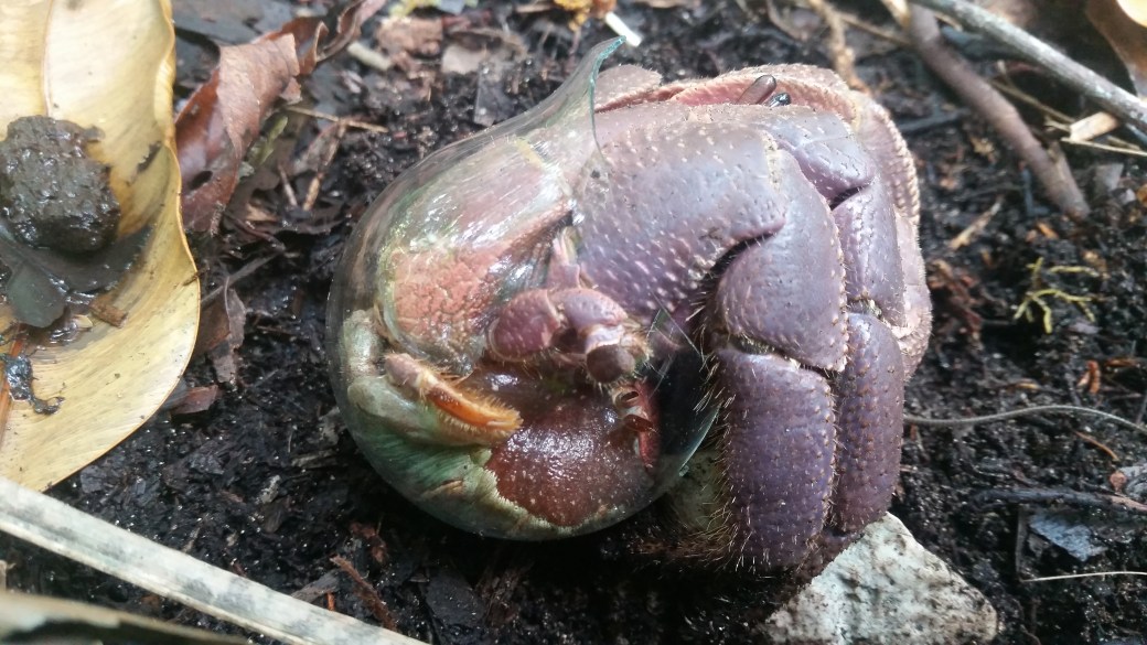
A resourceful coconut crab uses a broken lightbulb for protection. Pic: Mike Lohr
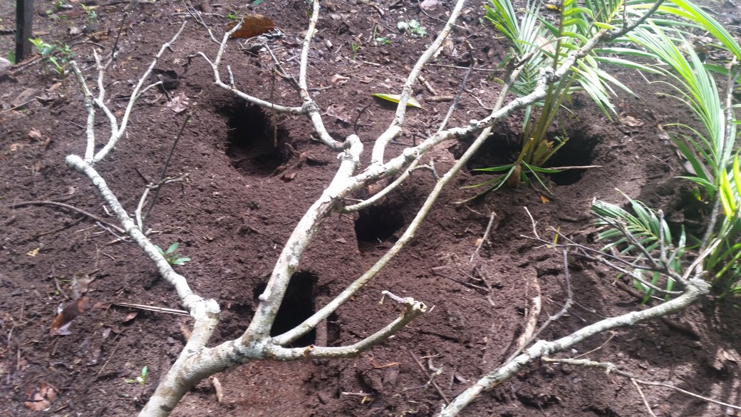
Excavations of a mound – is it megapodes or predators? Pic: Mike Lohr
December 31, 2016
Second field season begins!
The Palau Megapode team is back for a second field season, thanks to the generous support of Rufford Small Grants, the World Pheasant Association, The Centre for Ecosystem Management, Edith Cowan University and Club 300 Bird Protection Fund.
Paul Radley, PhD candidate has been on-ground for nearly 6 weeks already as it unfortunately took some time to get the permits and logistics sorted for this season. Things are now well underway, however, and this will be a short season, with a wrap up date of approximately 23 January. Boat access is restricted this season and what time on the water we do have was made possible by the generous contribution to our project by the World Pheasant Association. Ultimately, we have to fit all the data collection that we can into 19 days. Paul used his first four days of fieldwork to complete the first rat surveys in the Rock Islands using wax tags. One hundred of these peanut butter scent impregnated wax lures, known as WaxTags, were secured to trees on 10 islands in the Rock Islands Southern Lagoon. We chose five islands that experienced high levels of tourist visitation and five that experience little or none. The tags were left out for two nights, after which they were collected and the number of rat encounters quantified. We discovered that land crabs also tend to be attracted to the WaxTags and that there are indeed rats on all islands sampled. While 65% of tags on islands not visited by tourist had been sampled by the invasive mammals, 96% of tags on tourist visited islands recorded direct encounters. These data will later be compared with data from megapode surveys that Paul will be completing on the same islands to determine if there is a relationship between the numbers of rats on islands and the numbers of megapodes.
Stay tuned for regular updates
April 17, 2016
It’s a wrap!
Alii from Palau! As quick as a flash, the end of my first field season is upon me! As you read this, I will be on my way home to Australia. This past week was partly spent giving back to our supporters and stakeholders in Palau. I prepared a brief presentation for the Koror State Government about my progress this season. It focussed on key findings and went very smoothly. The audience seemed most interested in the number of new mounds located, how many were active, and if I had noticed any sign of poaching activity (which I hadn’t). Beyond that, given the short staffing at the Ranger’s office, I made it into the field only a couple times. The previous weekend (2-3 April) I had been in the Ngemelis islands where I finished getting locations for mounds on the remaining two large islands in the complex (Cheleu and Lilblau), adding 56 more to the list. This past Friday I was on Ngeanges island to practice a habitat data collection procedure, based upon direct observation of individual birds, referred to as instantaneous sampling. This will be employed further next field season.
As previously mentioned, I made it to Ngerechong in the far south-eastern portion of the Rock Islands lagoon this past Sunday to get GPS locations for megapode mounds there. This island was devastated by Typhoon Bopha in 2012 when it took a direct hit from the eye. When the storm passed over the island it was a Category 4 Super-Typhoon. It went on to devastate the Philippines as a Category 5 system with sustained winds of ~ 280 km/h (175 mph). Not surprisingly, on this island, many mounds were difficult to access and those that we could find in the single day we had, were often covered under heavy debris and obviously not in use. Of the 10 we managed to find, only two were active and apparently new since 2012. Looking ahead, the last few days this week will see me retrieving the 10 Reconyx remote cameras from their respective islands. I’ll also meet with The Nature Conservancy office in Palau to obtain recent GIS data layers for the archipelago and speak with the Palau Conservation Society collaborations next field season.
It has been a very busy but productive first field season. I’m looking forward to returning home for a while to analyse and write up the data to date. Thanks for following the blog and I’ll try to keep you posted after my return on any key findings.

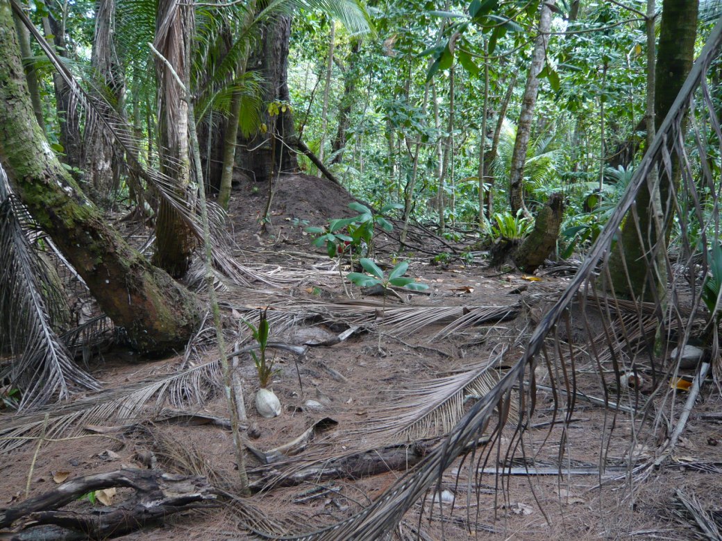
An active megapode mound on Cheleu, Ngemelis

An idyllic outlook: the 70 islands from Lilblau, Ngemelis.
Water shortage in Palau: a sign of things to come?
March 31, 2016
Progress was noticeably slower this week. I made it to the smaller but heavily tourist visited island of Babelomekang as well as the more isolated but likewise well visited beach at Ngeremdiu. At both locations I completed vegetation measurements at active mounds and acquired GPS locations of older ones. I also wrapped up veg work at two mounds on Dmasech in the Ngemelis complex of islands. This brings my total for vegetation data collection at active mounds and random sites to 24 each (48 total plots) and my total mound GPS locations to 64. Productivity this week was hampered by a combination of inclement weather (rain) and logistical issues. The current and ongoing ENSO event impacting the islands has taken a serious toll on Palau’s water reserves. This seems surprising for a tropical island and worryingly, ENSO events are projected to become both more common and more intense with ongoing climate change. As a result, the President of the Republic of Palau had this week declared the current water shortage a State of Emergency! Although the rain this week may have held up my work temporarily, it is certainly a welcomed occurrence by everyone.
Despite these setbacks to my progress, I found two new currently active mounds, from both of which I inadvertently flushed megapodes that were busy excavating; one at Ngeremdiu and another one on Dmasech. I set my last of 10 cameras at the mound on Ngeremdiu and already had a camera at the mound on Dmasech, aimed right at the area of action. Upon looking at the photos captured by this latter camera, however, I discovered that I again managed to miss all that action. Luckily, due to experience with this in the previous weeks, I had readjusted the aim of this and other cameras this week in an attempt to better line up their motion sensors with the top of the mounds their stationed at. I’m certainly hoping this will pay off. Lastly, the camera at an active mound on Dmasech interestingly captured a visit by people, who didn’t approach the mound but who showed curiosity towards the camera itself. The concern with this occurrence is that Dmasech is in a group of islands (the Ngemelis) that are a no go zone for tourists and the camera was set at a mound that was well off the “beaten path” and not in close proximity to a beach. This will be brought to the attention of the Koror State Rangers this upcoming week.
I have only 2 weeks left until the end of this field season so here’s hoping for a break in the weather and the chance to get out to the field a few more times.

Inclement weather over Ngeremdiu (P. Radley)
View upon approach of mound on Dmasech from which I flushed a megapode busy excavating. The bird was at the top of this mound, which is slightly over my head in height. The camera is positioned on a tree to the right of the mound in this view, but it can’t be seen in this image. This is typical habitat for many mounds on Dmasech. This one, like most the others on the island, is built around the base of a large Casuarina equisetifolia or ironwood tree. (P. Radley)
Non-photogenic megapodes give us the run around
March 22, 2016
A month of field work in and I have almost another month remaining. I feel that I’m reaching my fair quota of boat time but it sure beats the morning commute to work in heavy traffic! This past week I started visiting all inactive or old mounds on islands to acquire accurate coordinates with a Trimble DGPS. Differential GPS provides much more accurate location fixes allowing us to accurately map all mounds so we can examine the impacts of storm surges and sea level rise on megapodes. So far we have data on 62 mounds.
This week we had the excitement of checking our camera traps that we deployed on tourist islands and non-tourist islands, focussed on active megapode mounds. There were some mixed results. Some cameras especially near picnic shelters, seemed to attract extra attention, resulting in pictures of tourists on mounds staring at cameras, people pouring waste water onto mounds and all sorts of other activities! We had a few challenges with camera installation too, with a couple of cameras registering too few or no images due to installation issues. On our Dmasech Island study site, we set up a camera at a mound where I had actually flushed a bird. Unfortunately we got few pictures from this camera, but when we arrived at the mound after one week, the excavation made by the bird was filled in so it was clearly working the mound. While we continue to refine our camera trapping techniques, I will now begin a renewed focus on catching birds to build up a colour banded population for study. I am waiting for new nets of a larger mesh size to arrive from Australia in the meantime.
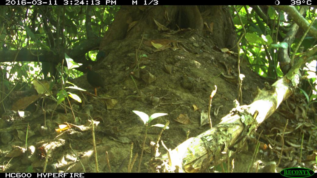
Megapode caught on camera trap on a mound at Ulong Island
Tidal surges a threat to megapode mounds
March 15, 2016
I’ve now completed my third full week of field work and things are moving along nicely. I have just spent the past three days camping on the island of Dmasech in the Ngemelis Complex, a group of islands that are a “no-go” zone for tourists and anybody without permission to access them for research. Local Palauans from Koror tend to have more ready access to these islands but I’ve been told that they tend to be just far enough away to discourage most locals from visiting. While searching for megapode mounds on these islands, we discovered that a good many that had been active in 2012 on the north side of the island had been destroyed by Typhoon Bopha that occurred in December 2012. However, we managed to find several newly active mounds on the south side of the island that had not been effected by the storm. With this visit, I managed to bring my sample size for habitat and vegetation mapping up to 20 mounds and 20 random plots. After one particularly long, hot, dehydrating day, we discovered that three of each is all we can sanely fit into one day! Upon returning to one of these mounds the next day to place a camera on it for monitoring, we flushed a megapode from it – and discovered that it had dug well into the top of the mound. I’m looking forward to seeing the images captured by our Reconyx cameras at this mound!


A view from Dmasech island (L), Ngemelis group at low tide (R) and an active megapode mound. Pics: P. Radley.
An unexpected and welcome capture during mist-netting activities was a juvenile Palau Ground-Dove. This enigmatic species may also be threatened and is also poorly known. It is another focus of our ongoing research projects on the islands.

Palau Ground Dove. Pic: P. Radley.
A megapode in the hand is worth a lot!
March 7, 2016
It’s been a few weeks since I’ve last posted. I apologize for that. Now that I’ve made it into the field, however (my first day was 19 February), things have been busy! After long, hot days in the field and the logistics and cost of merely finding a reliable and efficient internet connection, updates at times becomes a challenge! At this point my assistant and I have collected micro-habitat data on 13 megapode nest mounds and random sites across four separate islands in the Rock Islands Southern Lagoon (Ngeanges or Neco Island, Ngeroblobang, Ulong, and Ngeremeaus). We also deployed remote camera traps at a total of four nests on Ngeanges and Ulong, which will remain in place for at least the next few weeks. After two futile days of attempted megapode capture at Ngeanges, an ECU lab colleague and I managed to capture and individually colour band three at Ulong (see photos below). We could have probably caught and banded more than twice this number, but incorrect mist-net mesh size resulted in at least six birds eluding capture. We’ll work to correct his soon. As an aside, I thus far managed to get fairly good digital recordings of calls and songs for about six species of native bird, and, along with a local Kiwi birder, documented the first ever Palau record of Laughing Gull (Leucophaeus atricilla) in Koror. This upcoming week we’ll camp and collect data in the Ngemelis Complex of islands, which is a Palau conservation area with restricted access. As there is apparently a large number of megapodes and active mounds in these islands, the remainder of my first field season will probably involve a good many visits to them.


Clockwise from top left: a banded Micronesian Megapode, close up of custom-made Haggie bands, an active mound, Looking west from Ngeremeaus to Ngeanges and Ulong islands, and Ngeanges island study site. All pictures Paul Radley.
Research begins
February 18, 2016
After a long 3.5. weeks of organising permits, I finally have the green light to begin my research! With the support of our research partner the Koror State Government, managers of the World Heritage Rock Islands area in which the megapodes live, I’ll be going out each day on government patrol boats. I’ll be dropped off at an island each day and the initial focus will be on mapping megapode mounds and determining whether birds are choosing certain environmental attributes when placing mounds. If this is the case, it may have big implications for the future of this bird if key habitats become inundated from rising sea levels.

A megapode mound inundated by storm surges after a Typhoon in 2012. Pic: Rob Davis
Nearly there!
February 5, 2016
It’s approaching the end of week two of my first field season in Palau and I’m now living in new accommodation, in the State of Airai, where I will spend the remainder of the season.

My field accommodation in typical Palauan house of Chris Kitalong.
My accomodation is rustic and comfortable and in the morning I awake to the pleasant sounds of Palawan birds; the mournful hoots of Palau’s national bird the Biib (Palau Fruit Dove), the haunting tunes of the Palau Bushwarbler and Morningbird, the chatter of Caroline Islands and Dusky White-eyes, the screech of Micronesian Starlings and the flashy red Micronesian Honeyeaters (aka, Myzomela). At night I sometimes awake to hear the unusual hoots of the endemic and mysterious Palau Owl.
This week I managed to secure the last of my research permits from the local government; field work can now technically begin in earnest! I’m in a holding position, waiting to get my feet wet, as I wait for the Koror State Rangers (our research collaborators) to determine how they can best fit my transportation to the Rock Islands into their patrol schedule. This should be resolved by next week and I hope to be in the field collecting data shortly thereafter. Fingers crossed! In the meantime, I’m checking and prepping all my field gear, visiting hardware stores to search for necessary equipment (such as poles for mist nets). With the assistance of Dr Alan Olsen and Milang Eberdong I’m also refining nest vegetation measurements at a nature reserve on the island of Babeldoab. Things are coming together but I’m itching to start my project and start unraveling the mysterious life of the Palau Megapode!

The friendship bridge connecting the islands of Koror and Babeldoab.
It begins!
January 27, 2016
With more than 30 hours of transit time from Perth behind me, I landed safely at Palau International Airport at 01:05 on 24 January. After nearly an hour of sleep deprived manoeuvring through local immigration and customs, I was met by Dr Alan Olsen and Milang Eberdong (ornithologists from the Belau National Museum) who drove me to my temporary accommodation in Koror. I’ll move from here to more long term living quarters in the Palau state of Airai (not far from the airport, really) at the end of my first week. During my first week on the islands, I’ll submit an application for a scientific research permit with the Palau National Government, meet with Koror State Government staff, plan my research strategy organise logistics for getting out to the island study sites. Hopefully within a week or so, I will begin the exciting collection of research data. First up will be trying to figure out what habitat the Palau Megapode prefers to build it’s nest mounds in. I will also capture and colour band megapodes for individual identification, collect feathers from captured individuals for later genetic analysis, and place remote cameras at nest mounds to determine the extent of visitation by predators (rats and cats), people, and the megapodes themselves. During this entire time in the field, I will be collecting observation based data of megapode behavioural and movements, the latter increasingly facilitated by the establishment of a colour banded population. The location of the vast majority of this work will be the UNESCO World Heritage listed Rock Islands Southern Lagoon Conservation Area. Although I have a busy few months ahead of me, the spectacular study sites certainly make this an enviable location in which to work!

Surveying rat impacts on megapode will be an important research priority. Photo: Belinda Davis
